Trasan Village Inventory WebGIS
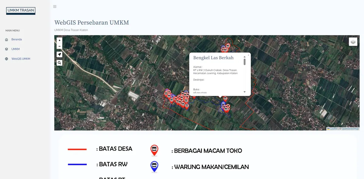
An interactive map of public facilities and potential distribution in Trasan Village.
Context
Trasan Village needed a spatial overview of its public facilities and potential for planning and promotion.
The problem is one many village governments share: the data on local potential already exists, but it lives as lists inside documents and Excel files. That form makes the most common questions hard to answer — where is it distributed, which areas lack a given facility, and which part of the village deserves priority at the next planning forum. A list cannot answer a question that is fundamentally about space.
The second need was promotional. Village potential is hard to communicate to outsiders — prospective partners, assistance programmes, visitors — when it exists only as prose with no sense of where things are.
What We Built
We built an interactive map showing the distribution of public facilities and village potential in a single, easy-to-explore view.
The architecture was deliberately kept light: Leaflet.js in the browser with PHP and MySQL on the server, no GeoServer. For a single village, the data volume sits far below the point where an OGC service layer starts to pay off, while a lightweight architecture runs on ordinary hosting at an annual cost a village budget can absorb. This is the choice we recommend for most village projects — adding GeoServer here would raise the cost without delivering a capability anyone uses.
Each map feature carries its own attributes, so a marker is not merely a dot on a map but a data entry that can be annotated and updated.
Key Features
- Public facility distribution map.
- Village potential visualization.
- Interface easy for residents to explore.
- Per-feature info popups with their attributes.
- Category grouping so the map stays legible.
Results & Impact
Village information became easier for the public to access. What changed is not only presentation: data previously understood by one or two village officials can now be opened by anyone from a phone, with no need to request a copy of a document.
For planning, the map became a shared reference when discussing development priorities — questions about which areas remain unserved can be answered by pointing at the map rather than debating from memory.
We note one limitation openly: the value of a map like this depends on the discipline of keeping it updated. The system provides the means, but continuity is determined by data governance within the village itself.
Need Something Similar for Your Village?
Village requirements tend to repeat: asset inventories, land parcels, public facilities, and local potential. If your village needs something comparable, see our WebGIS development service, or compare with the Smart Village WebGIS case study, which covers more ground by including digital letter administration.