Digital Twin City 3D
A Digital Twin prototype combining CityGML/CityJSON with 3D Tiles (photogrammetry, point clouds) and individual 3D models in one web platform.
Context
Cities and districts need a 3D digital representation for planning, simulation, and decision-making. We built a Digital Twin City prototype that renders an urban environment in 3D directly in the browser, with no specialized software required.
Spatial planning has long leaned on two-dimensional maps, yet some of its most important questions are inherently three-dimensional. What building height is still reasonable on a given block, how its shadow falls across neighbours through the day, and whether a proposal closes a sightline to a city landmark — none of these are answerable from a flat drawing.
The next obstacle is technical. A 3D city model is very large, while the desktop GIS software capable of opening it is not on every stakeholder desk. As a result, 3D models often end up as files only one or two people can open.
What We Built
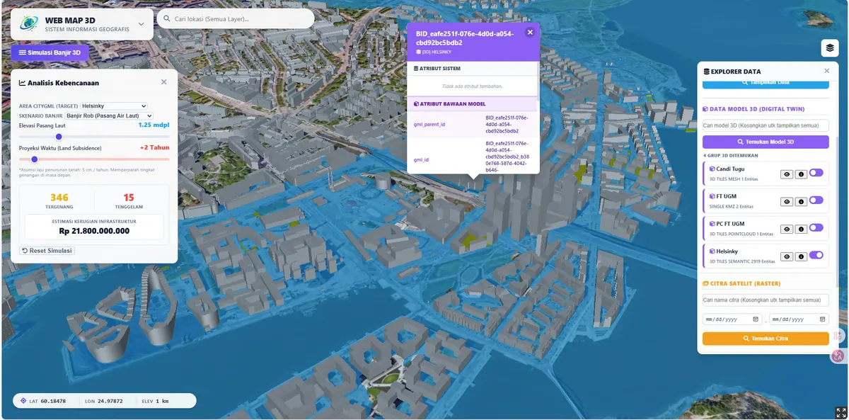
We combined CityGML/CityJSON city models with 3D Tiles from photogrammetry and point clouds, plus individual building models (GLB/KMZ). Everything is served through a CesiumJS-based web platform capable of efficiently streaming large 3D datasets.
Choosing CityGML/CityJSON is not merely a format decision. Both store the meaning of each building part — wall, roof, window — not just its shape. This is what separates a digital twin from an architectural 3D model: the city becomes queryable, for instance to filter buildings exceeding the permitted height in a given zone.
For load, 3D Tiles splits the model into a hierarchy of tiles at several levels of detail, then sends only what is currently visible at a resolution matched to distance. Without that mechanism, a city-sized area simply cannot be opened in a browser on ordinary hardware.
Key Features
- Interactive 3D navigation (pan, zoom, orbit) in the browser.
- Integration of photogrammetry, point clouds, and individual 3D models.
- 3D Tiles streaming for large datasets without overloading devices.
Results & Impact
The current demo uses data from Kalasatama, Helsinki, to show the maturity of the approach. The approach is ready for city governments, industrial estates, and developers.
Kalasatama was chosen because its 3D city model is openly available and complete, letting us demonstrate the technical maturity of the approach without waiting for equivalent local data. The workflow and technology are identical when applied to an Indonesian city — only the data source differs.
For an Indonesian city, the most economical route usually starts from data that already exists: building footprints extruded using a floor-count attribute. The result is simple blocks without roof detail, but already adequate for density, shadow, and sightline studies — and it can be upgraded in stages as budget allows.
Next Steps
We set out levels of detail (LOD), 3D data sources, and their cost implications on our Digital Twin City service page. For far more photorealistic object rendering, see 3D Gaussian Splatting.